By Timothy B. Wheeler, Bay Journal News Service
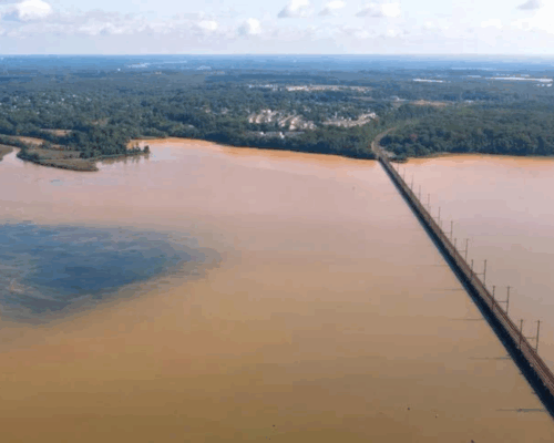
In low-lying spots bordering the Chesapeake Bay, it’s easy to spot the dead trees, leafless and shorn of limbs. These “ghost forests,” their gray trunks pointing skyward from marsh or open water, bear mute witness to the creeping inundation of coastal land as sea level rises.
The switch from lush green forest to a stubble of trunks and snags is so gradual that it’s often not noticed until it’s obvious. But now, a team of scientists is undertaking what they expect to be a decade-long study of the transition by repeatedly flooding a pair of forest patches at the Smithsonian Environmental Research Center (SERC) in Edgewater, Md.
Starting in June, each 2,000-square meter plot is to be doused periodically with 80,000 gallons of water. One will get freshwater, the equivalent of a 6-inch downpour in 10 hours. That’s many times the normal rainfall for the region, but it simulates the kind of extreme deluge that is predicted to become more common with the changing climate.
The other will get brackish water pumped from the nearby Rhode River, mimicking the episodic flooding from storm surges that are reaching progressively farther inland.
They’ll be watching for changes in the trees in both plots, which are mostly tulip poplar, red maple and American beech. But they’ll also be monitoring for less visible chemical signs of stress and decline.
“We’re interested in how the first storm surge that gets pushed up into a forest that has never had any exposure to seawater starts to impact the biology and the ecology of these upland forests,” said Pat Megonigal, an ecosystem ecologist and SERC’s associate director for research. “We know that just one isn’t going to kill the forest, so we’ll be running these 10-hour events … with increasing frequency, basically simulating what we hope is a 10-year period of rising sea level and storms washing farther and farther into the forest.”
More than 150 square miles of forest in the Chesapeake region have turned into marsh since the mid-1800s, one study estimates, and the rate of forest loss has been accelerating dramatically. Climate change combined with a gradual sinking of the land around the Bay are causing sea level to rise faster than in some other places, killing off trees and other vegetation that can’t tolerate the salty water.
(To read about research being done on Maryland’s Eastern Shore and in Virginia, where the effects are already dramatic, see Chesapeake Bay Magazine’s November 2021 feature story.)
Some studies have identified changes in the types of near-shore plants as early warnings of saltwater intrusion. This project aims to look for even earlier cues.
“We know that the forest will die,’’ Megonigal said. “What we’re interested in is: What’s the tipping point? And also, what are the mechanisms that dictate how the forest dies and how it starts to transform into marsh?”
It’s taken three years of planning and preparation to launch this large-scale field experiment, which appropriately enough is called TEMPEST (Terrestrial Ecosystem Manipulation to Probe the Effects of Storm Treatments). It’s part of a larger research project called COMPASS (with a full name that’s even longer), funded by the U.S. Department of Energy. With fieldwork in the Great Lakes and Bay watersheds, COMPASS aims to understand how coastal ecosystems respond to short– and long-term change.
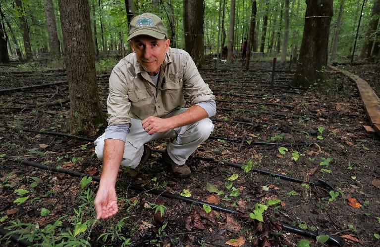
Researchers will pipe freshwater to the forest from large nearby storage tanks that must be replenished by truck. They will pump water from the Rhode a short distance uphill to a 20,000-gallon inflatable bladder that will be refilled four times during each simulated flood. The water dribbles evenly into the forest plots via an irrigation system. A network of sensors installed on the trees and in the soil feed data to a computer, enabling researchers to track the impacts in real time.
High-tech as it sounds, it involved some good old-fashioned shopping for parts. “I spent a lot of time at Home Depot trying to find the right thing,” said Anya Hopple, a post-doctoral researcher with the Pacific Northwest National Laboratory who’s leading the project. Her lab, part of the Department of Energy, is partnering with the Smithsonian center and several other institutions on the project.
Home Depot yielded the caulking needed to seal “flux chambers,” small boxes attached to the trunks of trees to capture the methane and carbon dioxide the trees absorb or emit through their bark.
Researchers don’t expect to see dramatic changes to the forest plot that will be flooded with freshwater. Those trees may actually benefit from inundation because their growth is typically limited in late summer when there’s usually little rain.
The patch to be saturated with brackish water should be another story. The salt stays behind in the soil when the water drains away, impairing tree roots’ ability to absorb the water they need to grow and survive.
“Each time you do it, you’re adding a little more salt to the system,” he said, “and there will come a tipping point where the trees here aren’t adapted to the stress and they’ll start to decline.”
The information gleaned from this study will be used in computer modeling to help scientists refine predictions of how quickly and extensively upland forests might respond to extreme weather and sea level rise.
“This isn’t going to stop sea level rise,” Hopple said. “It’s just going to help us understand how it unfolds.”