It may come as no surprise that the National Oceanic and Atmospheric Administration (NOAA) is predicting an above-normal hurricane season.
That’s because a week and a half before hurricane season begins, we’re already seen two named storms of 2020, the most recent forming just Wednesday morning. Tropical Storm Bertha was expected to bring heavy rainfall to South Carolina and Southwest Virginia, along with tropical storm-force winds.
Tropical Storm Arthur, which came up the Atlantic towards North Carolina, prompted the temporary closure of the Port of Morehead City, and then moved out to sea. Arthur was still expected to cause dangerous surf and rip currents at mid-Atlantic beaches after the storm was downgraded to a post-tropical cyclone on May 19.
The true hurricane season runs from June 1 through November 30 and NOAA’s Climate Prediction Center says there’s a 60 percent chance it will be an above-normal season. The chance of it being a normal season sits at 30 percent and there’s only a 10 percent chance of a below-normal storm season.
Of the 13 to 19 named storms NOAA is predicting, six to 10 could become hurricanes, and three to six of those could be major hurricanes (those with winds of 111 miles per hour or higher).
Federal disaster officials caution people that it’s as important as ever to prepare for the possibility of hurricanes along the coast, but this year that preparation comes with extra things to think about.
“Social distancing and other CDC guidance to keep you safe from COVID-19 may impact the disaster preparedness plan you had in place, including what is in your go-kit, evacuation routes, shelters and more… it is time to revise and adjust your emergency plan now,” said Carlos Castillo, acting deputy administrator for resilience at FEMA.
What’s fueling the “strong likelihood for above-normal activity” in the Atlantic this year? NOAA says there’s not expected to be an El Nino presence to suppress hurricanes, and other climate factors like warmer-than-average surface temperatures in the tropical Atlantic Ocean and Caribbean Sea, weaker trade winds, less vertical wind shear, and bigger west African monsoon also contribute.
The agency says it’s upgrading its technology for tracking hurricanes this year, including feeding satellite data (like air temperature, pressure and humidity in tropical regions, where hurricanes form) into weather models to track intensity and make forecasts more accurate.
Also in 2020, NOAA and the U.S. Navy will deploy a fleet of “autonomous diving hurricane gliders” to observe conditions in the tropical Atlantic Ocean and Caribbean Sea in areas where hurricanes have historically traveled and intensified.
The 2020 storm predictions will be updated in August, just before the historical peak of hurricane season. In August of 2019, NOAA’s update boosted the chances of a busy storm season from what the agency initially predicted in May.
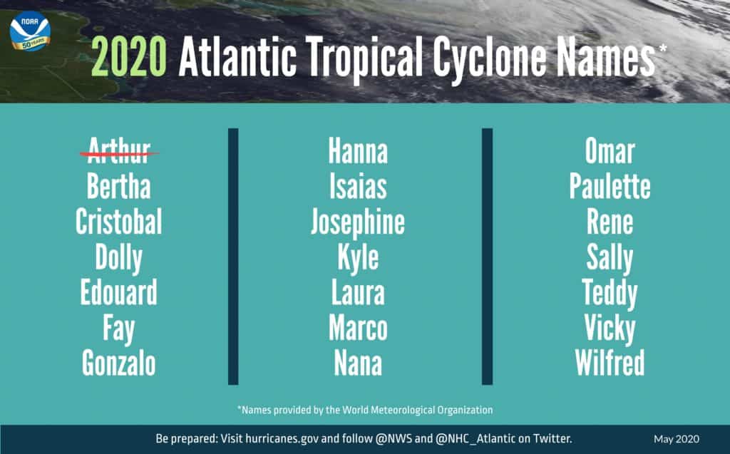
In case you’re wondering which names the World Meteorological Organization has come up with for 2020 storms, here’s the full list. Arthur, of course, has already been used, and Bertha is now underway.

-Meg Walburn Viviano


