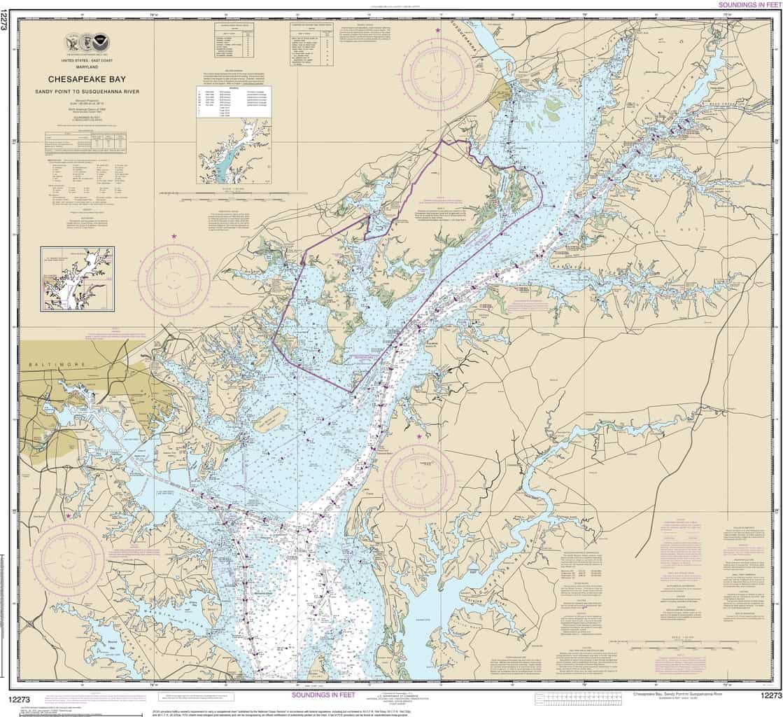
It was Capt. John Smith who started the confusion. He and his crew aboard the Discovery Barge thought that at the top end of the Bay they “might see the bay to divide in two heads, and arriving there we found it divided in four, all of which we searched so far as we could sail them,” according to his General History. Those four headwaters are what we know today as the six-mile-wide Susquehanna Flats, comprised of the half-mile mouth of the largest river, which he named for the upriver Susquehannock tribe, and the smaller Northeast, Elk and Sassafras rivers (the last of which Smith came to know by its Native tribe, the Tockwogh).
To Smith and his crew, the change certainly looked like a dividing point, with all four rivers deserving of names. The explorers could not have known then that the Bay is actually the tidal lower reach of a waterway that extends hundreds of miles to the North.
The unintended result of Smith’s naming process is four centuries of thinking about the Chesapeake and the Susquehanna as two different entities, when they are, ecologically speaking, two sides of the same coin. Fortunately, the Chesapeake Bay Program’s Clean Water Blueprint firmly integrates them in its multi-year restoration partnership.
It’s easy enough to appreciate the relationship with modern mapping systems, but the best way to absorb it is to explore this remarkable transition point by boat. The Susquehanna Flats have caught several millennia of rich sediment from central Pennsylvania and south-central New York. No wonder the area now grows one of the lushest, most diverse beds of underwater grass in the entire Chesapeake system. If you’re thinking of visiting by boat, there’s a marked channel around it. If you’re in an outboard skiff, kayak, or canoe, feel free to carefully explore it. There are actually multiple “shad ditches” cutting through the Flats. The combination of shallow grassbeds and ditches makes the Flats prime habitat for fish such as largemouth bass and yellow perch in warm weather, and migratory waterfowl including canvasbacks and Canada geese in the cold.
Meanwhile, the powerful currents of the Susquehanna running through Smith’s Falls, where the river bed drops to sea level, and the deep-though-short tidal river below have formed a conduit for multiple springtime spawning fish, including river herring (both alewives and bluebacks), hickory shad, American shad, white perch, and rockfish.
Worldwide, river fall lines and the navigable tidal water below have always drawn commerce, and the Susquehanna is no exception. Smith’s parley with the Susquehannock chiefs took place on the island because that was where their tribe had traditionally come to trade with the Tockwogh. In 1622, Edwin Palmer received a grant for the island from King James I and named it for himself. In 1637, Virginia’s William Claiborne set up an English trading post there, but after the Maryland Colony established its claim to land north of the Potomac, they evicted Claiborne and built a fort (a practice they continued further south at Kent Island). Onshore, a settlement called Lower Ferry developed where Perryville is today, helping people cross to Harmer’s Town (now Havre de Grace). Upriver, just below the Falls, Upper Ferry (now Port Deposit) connected with Lapidum.
Though the Susquehanna is shallow and rocky, the 17th- and 18th-century colonists who settled in Pennsylvania found ways to transport natural resources, especially timber, to connect with sailing ships. Naturally, shipyards developed on the town waterfronts to build, repair, and service both local and long-range watercraft, as well as ferries (which served the southern delegates to the Constitutional Convention in Philadelphia). Meanwhile, a strong culture dependent on subsistence harvest of fish and waterfowl developed between the Falls and the Flats. The 19th century brought steam power and a connection between Havre de Grace and Pennsylvania’s canal system. Soon, there was steamboat service (along with sailing packets) for the run to Baltimore, with overland travel continuing by coach to Wilmington and Philadelphia.
The War of 1812 came to Havre de Grace when British Admiral George Cockburn shelled and plundered the town in 1813, in spite of a valiant local defense. After the war, commerce returned to the region, along with produce farming, orchards and, of course, waterfowl hunting and fishing for the river’s then-massive American shad run in the spring. (With no dams to obstruct them, some of these amazing fish ran upstream all the way to Binghamton, New York to spawn.) The Baltimore & Ohio Railroad reached Havre de Grace by the 1850s, and in the 1880s the railroad bought Palmer’s Island to help build a bridge across the Susquehanna, re-naming it Garrett Island for the company’s president.
The late 19th century brought a riverside quarry just above Havre de Grace, which lies beside a channel deep enough at 13 to 30 feet to float large barges full of the quarry’s rock (some of which is used to build the substrate of restoration oyster reefs further south). That little channel may have been a creek that Capt. Smith and his crew explored in 1608. It lies inside a shallow bar about three feet deep, in the middle of the big river. Check a chart or your depth sounder if you’re out there; if you’re in a kayak or a canoe, you’ll be able to touch the hard, gravelly bottom of the bar with a paddle. It extends all the way up to today’s Lapidum Landing, part of Susquehannah State Park.
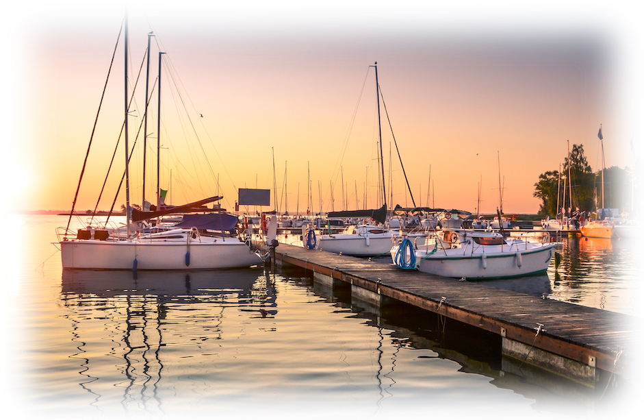
Today, this area has become a boating center for Lancaster, Philadelphia and Wilmington. Several old marinas and other businesses on the Havre de Grace waterfront have turned into condominiums, as has the former Owens Fish Company in Perryville (a remnant of the glory days of the shad runs). Tidewater Marina in Havre de Grace offers an important center for both sailing and powerboating, with a full set of repair services and a ship’s store. The other large marina there is the city-owned Millard Tydings Memorial Yacht Basin. There are smaller marinas and repair yards along the waterfront there, as well as in Perryville and Port Deposit.
Havre de Grace is well worth a longer stay. The waterfront includes a boardwalk along the riverfront, with paths leading to the Concord Point Lighthouse, the Havre de Grace Decoy Museum, and the Havre de Grace Maritime Museum. All are well worth visiting. A short distance upriver lies the Lockhouse Museum, located in the old stone lock keeper’s cottage beside the excavated terminus of the Susquehanna and Tidewater Canal, where barges transferred cargo to ships. Further upriver is Susquehanna State Park, which offers trails, river access at Lapidum Landing, and a number of cultural resources that give the flavor of this unique part of the Chesapeake.