The watershed’s rivers tell a story as old as time
Even though Great Britain is liberally endowed with rivers, somehow the English who came to the Chesapeake in 1607 didn’t understand that the waterways of the New World worked the same way. They and their bosses at the Virginia Company of London were convinced that the Great Bay of Chispioc could be the opening of the fabled Northwest Passage through the New World to the riches of the Orient. Thus their disappointment, as Captain John Smith put it, when, exploring up the James in that year, “we were intercepted with great craggy stones that [stand] in midst of the river, where the water falleth so rudely and with such a violence as not any boat could possibly pass.”
They had reached the river’s fall line, its head of navigation. That is the area where its bed, flowing downhill from Virginia’s Appalachian Ridges and Piedmont Plateau, reaches sea level on the Coastal Plain. From a geologic point of view, a fall line is actually a zone, rather than a single line, but more on that shortly. For practical shipping purposes, Smith had it right. That fall line marked an important transition point for human enterprise. No wonder that he, Captain Christopher Newport and the rest of that small expeditionary crew found an established Native village there led by Parahunt, a son of the region’s Paramount Chief, Powhatan.
Through his exploratory voyages in the summer of 1608, Smith visited and mapped the fall lines of all of the Chesapeake’s western shore rivers. The extraordinarily accurate map he published in 1612 served rapid colonization of Virginia and Maryland, though the English treatment of Native communities would prove far less than honorable. As the 17th century progressed, English colonists established trading centers at the fall lines on all of those waterways, as well as the less dramatic heads of navigation on the Eastern Shore rivers. A secondary benefit of those locations was the rapid change in elevation “where the water falleth so rudely.” The resulting energy release made the fall lines good locations for water mills, gristmills and sawmills. We know today that those trading centers turned into villages, then towns, and by the booming 19th century, into cities.
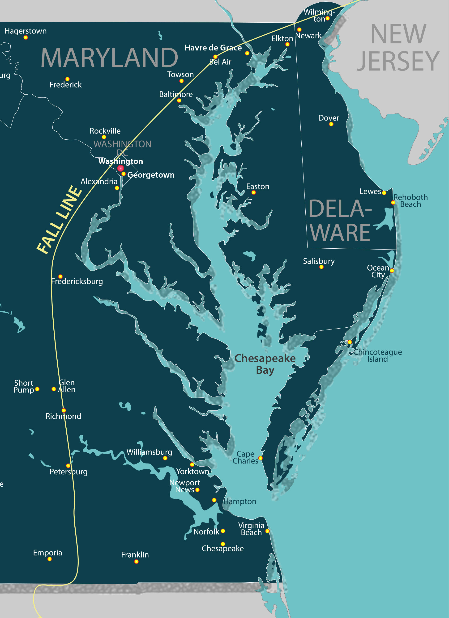
Today, Interstate 95 and old U.S. Route 1 run roughly up the Chesapeake’s western shore fall line. It’s no accident. Once highways took over from rivers for transportation of people and goods, planners laid out those roadways simply to connect the old port cities, from Petersburg on the Appomattox, Richmond on the James and Fredericksburg on the Rappahannock to Alexandria and Georgetown on the Potomac, Elkridge and Baltimore on the Patapsco and Havre de Grace on the Susquehanna. Although the pattern is not as clear on the Eastern Shore, there are cities and towns at or near the heads of navigation on the rivers there, for the same commercial reasons. Each is on a highway. Examples include Millington on the Chester (U.S. Route 301), Denton on the Choptank (Route 404), Seaford (Del.) on the Nanticoke (Route 13), Salisbury on the Wicomico (Route 13), and both Pocomoke City (Route 13) and Snow Hill (Route 12) on the Pocomoke. All those river ports hosted commercial traffic into the mid-20th century before the highways took over transportation. Salisbury still receives regular bulk shipments by river of western shore corn and soybeans for Purdue’s chicken feed mill, and most of these municipalities still have sand-and-gravel operations moving product on their waters today.
From a geologist’s point of view, a fall line (or fall zone) is a section of river where a surrounding upland (Piedmont) region meets a coastal plain. The Chesapeake watershed’s Piedmont sits on hard crystalline basement rock, while its coastal plain is softer gravel, sand and mud washed down from the Appalachian and Blue Ridge Mountains over hundreds of millennia. Thus the coastal plain has worn away faster, creating abrupt elevation changes of 50 to 100 feet and resulting rapids. Millions of years ago, those mountains rivaled the Himalayas in height, but rainfall, freezing, thawing and much time have worn them down, creating the rich soils of the Shenandoah Valley, the Piedmont and the coastal plain.
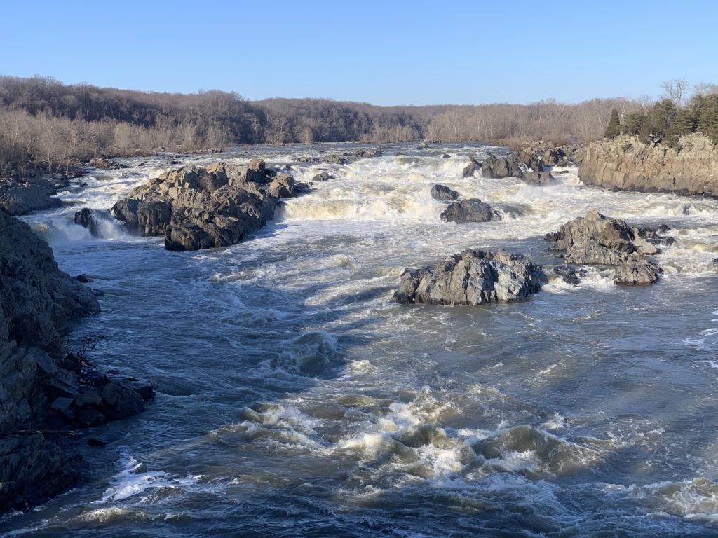
In that light, it’s worth noting that on an Earth time scale, a fall zone is not a static feature. It recedes upstream as the river slowly wears down the rocks over which it falls, exposing bedrock shoals. Remember that the underlying rock layers of the Chesapeake’s western uplands are not uniform in composition and hardness, either in north-south or east-west directions. Each river has carved its own channel, characteristic of the rocks under its bed. In a river with high flow, the abrupt drop that causes a waterfall may be miles upstream from the geologic boundary between the Piedmont’s bedrock and the Coastal Plain’s loose sediments, at significantly higher elevation. The waterfall has slowly migrated upstream, towards the west, as the river has eroded the bedrock at the eastern edge of the Piedmont. Geologists tell us the Potomac has etched the upper lip of its Great Falls 14 miles upstream to an elevation around 150 above sea level during the last 2 million years, running over broken rock remnants—including Little Falls—until its bed reaches tide downstream around Theodore Roosevelt Island and the Kennedy Center. Thus, the Potomac’s fall zone has stretched out for that distance.
By contrast, the North Anna and South Anna Rivers (the headwaters of the Pamunkey, and thus of the York), with smaller flows originating only in the Piedmont, begin their fall zones at elevations around 50 feet and drop to sea level very quickly, so the zones are much shorter, measuring in yards rather than miles.
For a fuller picture of the Chesapeake’s fall lines, it’s worth remembering the forces that shaped these river systems. Over the past 500,000 years, the Chesapeake watershed has gone through three periods of glaciation in which the sea level dropped as much as 500 feet while the climate turned cold and locked up water in glaciers to the north during an Ice Age.
In these times, the main river (today’s Susquehanna) flowed from the edge of its glacier in today’s central New York and Pennsylvania. Bounded to the west by the Appalachian and Blue Ridge Mountains and the Piedmont plateau, it ran south and east, gathering all of the other Chesapeake rivers as tributaries in its lower reaches. On the east, its boundary was the growing spit of coastal plain land built from the Atlantic’s longshore flow and sediments from the Hudson and Delaware rivers.
We know that spit today as the Delmarva Peninsula. It is built on coastal plain gravel, sand, and mud, so its rivers don’t have strict fall lines with rocky rapids. As they carry rain off higher ridges of land, though, their beds reach sea level at the points noted above.
Between its western and eastern shores, the big river cut its channel far across the continental shelf to reach the Atlantic in the region of today’s Norfolk Canyon. During this time, all of the rivers carved deep channels into their geologically diverse beds.
Around 300,000 years ago, the climate warmed up, the glaciers melted and sea level rose, backing up into the big river’s valley to create an estuary of roughly the same length as today’s Bay. Its mouth appears to have been perhaps forty miles further north, because the Delmarva Peninsula had not grown as far down the coast. In (long) time, sediment filled that estuary. Another Ice Age and thaw around 150,000 years ago created another Bay with a mouth about twenty miles north of the current one. It too filled in before another Ice Age dropped sea level again. Our Bay began forming about 18,000 years ago, as that most recent Ice Age thawed. It reached its current basic shape about 3,000 years ago, though we know all too well that that shape continues to change before our very eyes.
The story of our rivers’ fall lines carries an important lesson for us. Our Chesapeake is a dynamic system, changing subtly by our quick-time standards, but inexorably. There’s an old saying that “Mother Nature still makes the rules, and She always wins.” We do well to learn to work with her, rather than against.
Note: If you’d like to read a good non-technical summary of this process, check out Chesapeake Quarterly, the magazine of the Maryland Sea Grant Program, at chesapeakequarterly.net. Look in the CQ Archive for Volume 10, Number 1 (2011), The Bays Beneath the Bay.
CBM Editor-at-Large, educator, guide and author of three quintessential Chesapeake Bay books, Capt. John Page Williams was named a Maryland Admiral of the Bay in 2013.