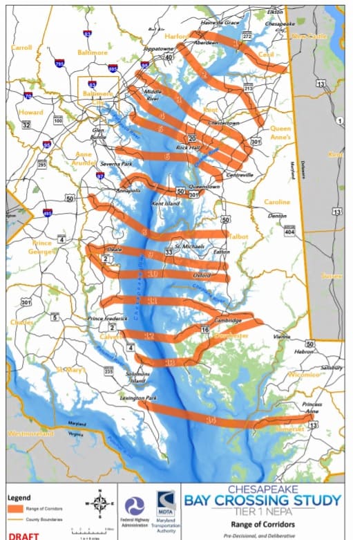
A set of map drafts from the ongoing Chesapeake Bay Crossing Study has gone public, revealing 14 different possible locations for a future crossing in Maryland.
The National Environmental Policy Act (NEPA) study aims to find “a preferred corridor alternative to address congestion at the Chesapeake Bay Bridge and evaluation of its financial feasability.”
The study will evaluate the current future traffic demand across the Chesapeake Bay. It’s being conducted by the Maryland Transportation Authority (MDTA), which owns, operates and maintains the Bay Bridge.
According to recently-surfaced map drafts from MDTA and the Federal Highway Administration, the farthest-north possible bridge could cross from Harford to Cecil County, and the farthest-south could cross from St. Mary’s to Somerset County. Between the two, there are 12 other possible locations shown— including a span that would cross right next to the existing Bay Bridge.
The draft maps show the possible crossing locations compared to different geographical factors: one map shows the locations by county, another highlights areas of prime farmland and wildlife refuges, still another marks wetlands and 100-year floodplains.
In a statement to Bay Bulletin, MDTA spokesman John Sales stresses that the maps being circulated are far from final proposals:
“The pre-decisional maps that are part of the Bay Bridge Tier 1 NEPA process are just that, pre-decisional. The MDTA is working toward formal presentations of the proposed alternatives and that is scheduled to happen this spring.”
The study— and any possible locations— has set off a “Not in my Backyard” reaction from some groups both on the western and Eastern Shores. The organization Keep Calvert Country is pushing for county commissioners to take a hard stand against a bridge crossing in Calvert. There are four possible Calvert County locations on the pre-decisional maps. Keep Calvert Country shared the set of map drafts; you can see them by clicking here.
The Kent Conservation and Preservation Alliance opposes any new Bay crossing, especially one that ends in Kent County. The group calls it a “20th century solution to a 21st century problem.”
“Instead, take the money that would be spent on this infrastructure project, upwards of $6-7 Billion, and use it to improve the communities and infrastructure of the State, making them more livable and sustainable thereby reducing the desire to commute long distances, including across the Chesapeake Bay.”
In 1952, 1.1 million vehicles traveled over the Bay Bridge. In 2014, that number was 25.5 million vehicles. And MDTA maintains that traffic volume over the Chesapeake Bay is only going to get heavier in the future.
The Chesapeake Bay Crossing Study website notes that a set of public open houses scheduled for this winter, will now be delayed into spring due to the partial government shutdown. “Key federal partners,” the site explains, were unable to attend meetings or review the study’s progress while government employees were furloughed.
When the new open house dates are announced, they’ll be posted here.
-Meg Walburn Viviano


