Changes are coming to the data-collecting “smart buoys” deployed around the Bay.
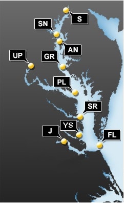
This map shows all current buoy locations. The Chesapeake Bay Interpretive Buoy System records everything from air and water temperature to probability of nettles.The National Oceanic and Atmospheric Administration’s (NOAA) Chesapeake Bay Interpretive Buoy system gathers information on weather, water conditions and water quality at specific locations around the Bay. The information is transmitted wirelessly to the web for scientists, boaters, and the general public to use.
NOAA has been working to replacing aging buoys with new, smaller buoys. But some, used frequently by anglers, won’t be replaced. NOAA released this list detailing each change to the status of the buoys:
-
Barring any last-minute hurdles, the buoy team plans to deploy a new buoy at the Annapolis location in very early May.
-
A new buoy was deployed at Jamestown; the buoy technical team is working on repairs to make the buoy fully operational.
-
Potomac is currently an old buoy that has failed (likely due to water intrusion resulting in damage to electronics); plans are in the works to swap a new buoy in at this location in early May.
-
Stingray Point and Gooses Reef locations (including bottom lander at Gooses Reef) are operational with new buoys.
-
York Spit and First Landing currently are operational with old buoys; the team is working to acquire needed electronics to enable swapping old for new buoys, anticipated deployments in June.
-
Patapsco currently has no buoy; it is under construction, and the anticipated launch date is still to be determined. This buoy supports commercial shipping as ships transit into Baltimore.
-
It does not appear we will deploy buoys at the Upper Potomac or Susquehanna locations in 2019. We know there are recreational fishermen who use data from these locations. The “CB1.1 Susquehanna River” data from Maryland Department of Natural Resources’ Eyes on the Bay network provides data that can be helpful for anglers, including water temperature and salinity. For Upper Potomac, the “TF2.1 Off Piscataway” Eyes on the Bay location is a few miles downstream of the Upper Potomac buoy location, and another NOAA station that includes water and meteorological information is upstream a few miles at Washington, D.C.
For more information on the Chesapeake Bay Interpretive Buoy System and to access data online or with its mobile app, click here.
-Meg Walburn Viviano


