By Jeremy Cox, Bay Journal News Service
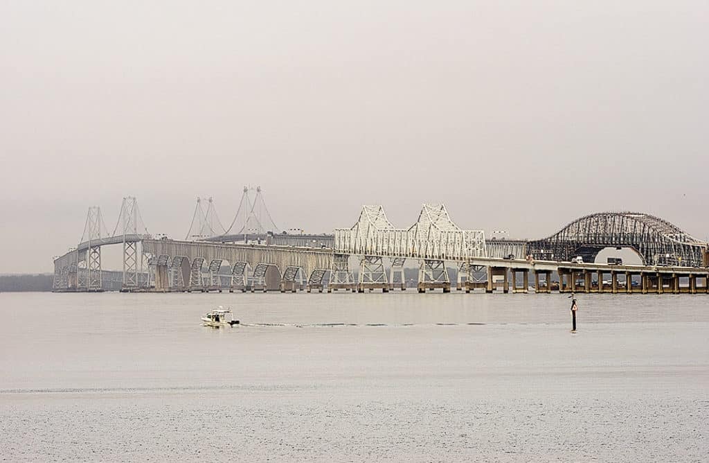
Maryland transportation officials recommend building a new Chesapeake Bay bridge at the site of the existing two spans that cross between Anne Arundel County and Kent Island.
The project will cost from $5.4–$8.9 billion, depending on which construction methods are chosen. But a preliminary study concludes that the new crossing will prevent increasing traffic volumes from causing gridlock on the state’s lone connection to the Eastern Shore across the Bay.
The Maryland Transportation Authority, which operates the existing four-mile toll bridge, released the long-awaited findings Feb. 23 in a draft “environmental impact statement.” The $5 million study had been scheduled for release in December 2020, but officials delayed the rollout amid a spike in COVID-19 cases during that month, fearing it might suppress public comment.
Many environmentalists question the need for a third crossing, saying that officials are overestimating projected traffic growth between the two halves of the state.
The Transportation Authority study began with 14 potential corridors, spread across more than 100 miles, from the top of the Bay to the Virginia border.
Those were narrowed down to three options. From north to south, the possible routes would cross the Bay from Pasadena to Centreville; at the existing bridge site from east of Annapolis, near Sandy Point State Park, to Kent Island; or from the Mayo Peninsula in Anne Arundel County to near St. Michaels in Talbot County. A “no-build” option also was considered.
Neither the Pasadena-Centreville nor the Mayo-St. Michaels routes would divert enough traffic away from the existing bridge to keep them from becoming overwhelmed with traffic during peak times in 2040, according to the study’s estimates.
With no improvements, the existing spans are projected to carry 135,300 vehicles on a typical summer weekend day in 2040. By running a new crossing at the same location, that total falls to 79,700, a 40 percent decline. This was by far the largest decline among the 14 possible corridors, the study found.
Cost estimates top out at $7.2 billion for the northern option, $8.9 billion for the current location and $15.7 billion for the southern option. Choosing a bridge-tunnel hybrid would add $3-$5 billion to each scenario, according to the report.
The report identifies the existing crossing location as the “preferred corridor alternative.”
That option is likely to have fewer environmental impacts as well, according to the study. That’s because the water crossing is shorter than its counterparts, and the route can take advantage of existing land-based infrastructure. The northern and southern routes likely would have “greater impacts to sensitive environmental resources in and around the Chesapeake Bay, especially tidal wetlands and aquatic resources,” the analysis says.
The analysis agrees with many of the project’s detractors that the northern and southern routes could also increase demand for unplanned development in the Eastern Shore’s rural areas.
Since 1980, the annual number of vehicles crossing the bridges has soared from 10 million to 27 million, according to the report. With no changes to the bridges, typical weekday traffic is expected to increase by 23% by 2040, while summer weekend day traffic will grow by 14% in those two decades.
A recent analysis funded by the Queen Anne’s Conservation Association, an Eastern Shore environmental group, suggests those projections are inflated. That report argued in part that the state’s weekend traffic estimates are based on the measurement of one day of traffic in August, when traffic is significantly heavier than a typical summer weekend day.
Critics also have pointed to the coronavirus pandemic as a reason to reconsider the span. The virus and resulting lockdowns have upended the way people live and work, with many telecommuting and choosing vacations closer to home.
But the Transportation Authority rejected using any pandemic-related effects in its report.
“We will continue to track trends in travel behavior and traffic volumes as our communities, businesses, places of worship, and schools begin to reopen, and [we will] consider new information as it becomes available,” the authors wrote.
Bridge opponents have pushed the state to consider other modes of travel to get people across the Bay.
The authority did outline four potential alternatives to a bridge: electronic no-stop tolling, a ferry service, bus rapid transit and a new rail line. The agency eliminated all of those as stand-alone options and permanently nixed any consideration of a rail line, which it deemed prohibitively expensive. The remaining alternatives, however, will continue to be analyzed.
To get public feedback, the state has scheduled four call-in sessions and two in-person meetings, all in April. Comments are being accepting until May 10.
The call-in hearings are set for 1–3 p.m. and 6–8 p.m. on April 14 and 15. To register to provide testimony, call 877-249-8370. In-person meetings will be April 21 at the DoubleTree by Hilton at 210 Holiday Court in Annapolis and April 22 at the American Legion Hall at 800 Romancoke Road in Stevensville.


