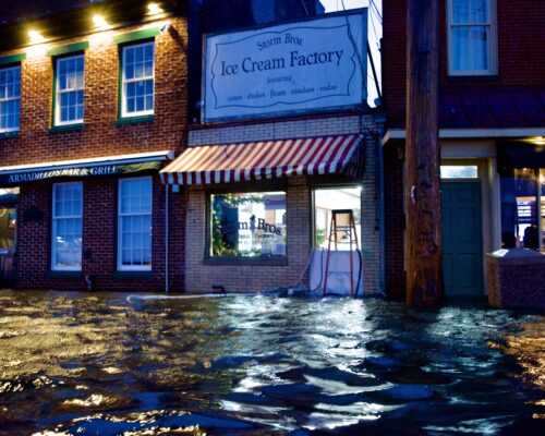
By Timothy B. Wheeler, Bay Journal News Service
Storms and erosion have taken their toll on this beach on the western shore of Deal Island. As the Bay’s water has encroached, trees have died; some are no more than stumps in the water now. (Dave Harp)The sand dunes that used to line the western shoreline of Deal Island are almost all gone. So are the trees that stood behind them on this low-lying patch of land jutting into Tangier Sound on Maryland’s Eastern Shore. All that remains now are stumps poking up out of the waves, which wash over a narrow, sandy beach and up into a grassy marsh stretching far inland.
“See the tree in the water?” asked SueKay Ford, pointing to a barren snag just offshore. “That used to be standing on the shoreline,” she said, when she moved to the neighborhood 14 years ago. “It used to have an eagle’s nest.”
Before many more years have passed, homes for humans on Deal Island could be jeopardized as well. Erosion, storm surges and even fair-weather flooding are chronic or repeat threats. The impacts extend far inland on this stretch of the island’s shore where there’s a “ghost forest” of dead trees, killed because their roots have become too wet to survive.
With 7,000 miles of shoreline, Maryland is particularly susceptible to the impacts of sea level rise, storms and flooding, and the western shore of Deal is particularly vulnerable because of its exposure to the wind and waves of the Bay. State officials and scientists are teaming up now, though, in an effort to help this community of about 400 people that is already losing ground to those threats.
The Maryland Department of Natural Resources is planning to restore the lost dunes along a 1,200-foot stretch of Deal’s western shoreline. Construction is expected to start in the summer of 2019, according to Nicole Carlozo, resiliency planner in the DNR’s Chesapeake and Coastal Service. The dune restoration is one of 12 projects approved for funding by the state Board of Public Works in 2017 and earlier this year to demonstrate coastal resiliency measures that communities can take.
Meanwhile, researchers from George Mason University in Virginia are trying to get a handle on how the marsh at Deal Island, and possibly other features along its shoreline, may be reducing the erosive power of the Bay’s waves. Their findings could help the state design its dune restoration project and other measures intended to reduce erosion or prevent flooding.
“We know that previous research showed that [habitat, particularly forest and wetlands] reduces flood impact by reducing wave levels during a storm,” said Ali Rezaie, one of the doctoral students working on the project, during a visit to Deal Island this summer. “But to use nature as a form of flood protection — to engineer something — we need to quantify, we need to design it.”
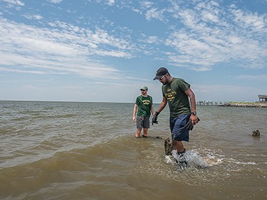
Earlier this year, Rezaie and his research partner, Juan Garzon, installed small, battery-powered wave and flow sensors in the shallows, on the beach and in the marsh. They returned in July to retrieve the data those sensors had been collecting. In addition, they brought along an acoustic Doppler current profiler, which they can deploy in the water to measure the currents and water velocity from the bottom to the surface.
On land, they have been chronicling the vegetation growing back from the beach, counting the number of marsh grass stems in a standard plot and measuring their height and thickness through the growing season.
The George Mason research is underwritten by $30,000 in grants from The Nature Conservancy, which has been working to better understand the resiliency of Maryland’s wetlands to climate change. Ariana Sutton-Grier, director of science for the Conservancy’s Maryland and District of Columbia chapter, joined the researchers for their Deal Island visit.
“The goal of the project is to better understand how different features in the landscape are helping to attenuate or slow down wave energy, and as a result, helping to prevent erosion and flooding risk,” Sutton-Grier said. She said the study is particularly useful because there hasn’t been much research on natural wave attenuation.
“What they’ll do with their measurements,” Sutton-Grier explained, “is actually model how much wave energy is coming in and how much it decreases as it goes through the various natural components.”
In a 2013 report for the Maryland Climate Commission, scientists predicted that sea level rise, combined with gradual land subsidence, could raise waters in the Chesapeake Bay by as much as 2.1 feet by 2050. By the end of the century, they projected the increase could be 3.7 feet or higher. Much of Deal Island is just 3 feet above sea level now.
But a hurricane-driven storm surge could cause flooding that high or higher much sooner, putting hundreds of Deal Island residents’ homes at risk. Tropical Storm Isabel in 2003 produced a surge in excess of 7 feet in parts of the Bay.
A 2016 study done by The Nature Conservancy and the DNR pointed out that coastal habitats, such as forest and wetlands, can reduce flooding and erosion. Marshes are particularly important around Tangier Sound, where Deal Island is located, but the bulkheads and riprap that line much of the shore on the island and elsewhere prevent marshes from providing that protection.
The Nature Conservancy funding helped to pay for the sensors the George Mason researchers have deployed and for the time they have spent making the three-hour trek from the university’s campus in Fairfax County, VA. The team has already taken some measurements farther south along Virginia’s shore but, in consultation with Sutton-Grier, they also selected Deal to study because wave action appeared pronounced there. The beach faces a long fetch of open water, which enhances the tendency for winds to whip up waves.
Juan Garzon, a doctoral students in coastal engineering at George Mason University, holds an acoustic Doppler current profiler, which is deployed in the shallows to measure currents or water velocity from the bottom to the surface. (Dave Harp)
From earlier research that he’s done with other colleagues, Rezaie said, he’s learned that Maryland’s coastal wetlands have helped to prevent anywhere from $55 million to $454 million in property damage from hurricanes and tropical storms. The amount of prevented damage goes up with the strength of the storm, according to the research, which means that wetlands may become increasingly valuable if, as some scientists predict, climate change brings more intense storms.
The George Mason researchers’ analysis, which they hope to publish next year, may help make the case for preserving or restoring coastal wetlands. The study may also provide tips to environmental engineers charged with designing flood-prevention projects that use elements of nature.
The research on Deal Island’s shoreline is of great local interest, Sutton-Grier said. Residents fear that, with the dunes gone, erosion could take out the marsh next and remove the community’s remaining natural buffer against waves.
“So,” she added, “the community is quite concerned about the fact that additional erosion may actually lead to increased flooding of their neighborhoods and on their roads.”
Many residents in rural areas of the Shore say that erosion, not sea level rise, causes their flooding problems, but Ford — who’s running for a seat on the Somerset County Board of Commissioners — says it’s clearly more than that.
“The waters are rising,” she said, adding that she’d like to see the county enhance and better maintain its network of roadside ditches to help counter the water’s incursions.
Some roads on Deal Island already flood, Sutton-Grier noted. Restoring the dunes won’t change that — nor stop the rise of Bay waters.
“There’s still going to be flooding,” she said. But, she added, “It’ll give the community more time.”