The University of Maryland Center for Environmental Science (UMCES) has deployed a new tool to track hurricanes—from underwater.
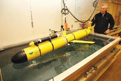
UMCESIn the midst of an especially active hurricane season, UMCES Horn Point Lab launched an underwater glider called Striper, to patrol the East Coast and collect hurricane data that can improve forecasts in the future.
There is a “cold pool” hidden below the surface of the Atlantic Ocean stretching from Cape Cod to Cape Hatteras, that can be stirred to the surface when a hurricane comes along. Cold water at the surface can affect the intensity of the hurricane, explains Bill Boicourt, professor emeritus for UMCES who oversaw the launch. He points to 2011’s Hurricane Irene as one of the storms that was affected by the “cold pool”:
“Irene’s intensity was overpredicted by 50 percent because the time evolution of ocean surface temperature is not included in the forecast models.”
Since then, the National Weather Service has called for a national glider plan to maintain a fleet of gliders patrolling the East Coast shelf during hurricane season to help with forecasting.
Striper was launched off the New Jersey coast, just north of Atlantic City. Its torpedo-like hull is about 6.5 feet long, and can glide up and down to different depths like a submarine. Striper has already turned toward Delaware Bay, and will travel to the edge of the shelf south of Baltimore Canyon, before it heads to Wachapreague, Virginia, where scientists will retrieve it.
UMCES explains how you can use Google Earth to track Striper in real time. Follow these steps:
1. Visit this site and under the title “Deployed Glider KMZ Files,” click on the first Google Earth icon (under the word Gliders). This will allow you to download a kmz file you’ll need to view the gliders.
2. Open Google Earth (This works best if you use the application rather than the web browser version, so you might need to download it to your computer). In Google Earth, go to File, then Open, and select the kmz file you downloaded. Under the Places menu on the left-hand side of the screen, you will see listings for Striper and other gliders. Click on each to see where in the world these gliders are located.
3. You can also view graphics of real-time data on the original website where you downloaded the kmz file. Select the glider you want to know more about and then click “view imagery” to see the transect plots.


