By Timothy B. Wheeler, Bay Journal News Service
The Trump administration announced plans to severely restrict the types of streams, wetlands and other waterways that would be protected by federal regulation from development or disturbance. Though welcomed by farmers and developers, the announcement drew intense criticism from environmentalists.
The U.S. Environmental Protection Agency and the Army Corps of Engineers jointly unveiled a proposed new definition of “waters of the United States” that would withdraw federal oversight of streams that only flow after it rains and of wetlands that are not physically connected to waterways. Acting EPA Administrator Andrew Wheeler said the proposal would take the place of a more expansive definition of federally protected waters, adopted by the Obama administration in 2015, which has drawn the ire of landowners wishing to develop or farm their property. He said the new definition “puts an end to the previous administration’s power grab.”
“For the first time, we are clearly defining the difference between federally protected waterways and state protected waterways,” Wheeler said in a statement. “Our simpler and clearer definition would help landowners understand whether a project on their property will require a federal permit or not without spending thousands of dollars on engineering and legal professionals.”
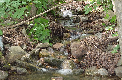
An ephemeral stream in Virginia’s Shenandoah Valley. Ephemeral streams would be exempt from federal protection under the newly proposed rule. Photo: Ari Phillips/Environmental Integrity ProjectThe proposal is the first step of a lengthy rule-making process and, if the rule is finalized, it would likely be challenged in court.
The new definition would provide federal protection for six types of waterways, including navigable rivers and their tributaries, lakes and ponds, as well as wetlands that are clearly connected to flowing water. It would cover streams that dry up at times, as long as they flow at some point in a typical year.
But it specifically exempts 11 other categories, including “ephemeral” streams, which only flow when it rains or snow melts. Also withdrawn from federal oversight would be freshwater wetlands that are isolated from other bodies of water.
Wheeler said the proposal would have no impact on federal regulations intended to ensure safe drinking water, nor would it affect ongoing restoration efforts in the Chesapeake Bay and other watersheds around the nation.
The Ecological Society of America, a nonprofit organization of more than 9,000 professional ecologists, responded to the announcement with a statement stressing that wetlands, streams and adjacent waters are “intrinsically connected” to the chemical, physical and biological integrity of navigable and interstate waters.
The society said that the rule the EPA seeks to replace was developed using the best available science, technical experts and more than 1,000 peer-reviewed scientific studies.
“Today’s action by the EPA undermines the use of the best available science showing strong benefits of protecting wetlands and upland watersheds,” said Laura Huenneke, president of the society.
Environmental groups and Democratic lawmakers also blasted the move, threatening legal challenges, as well as disputed the EPA administrator’s assurances that the Bay would not be affected.
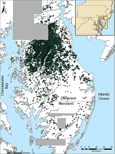
The Environmental Integrity Project criticized the proposed rule and issued a report citing data from the University of Maryland that suggests 54 square miles of wetlands on Eastern Shore farmland could be left with little or no protection. Known as “Delmarva potholes,” these nontidal wetlands are found in low-lying areas of Delaware, Maryland and Virginia and are usually not connected to the surface waters of nearby rivers or streams.
Still, researchers say they play an important role in filtering polluted runoff, providing amphibian habitat and reducing the risk of local flooding. According to the report, Maryland regulations could protect the Delmarva potholes in certain cases. Virginia’s likely would not: The state is prohibited by law from enacting wetland rules that are more restrictive than federal regulations.
Sen. Ben Cardin, D-MD, said that wetlands are critically important as water-quality filters in the Chesapeake region, adding that those in upstream areas are in jeopardy of losing legal protection. Many people’s drinking water comes from headwaters, he noted, and they may also be left vulnerable to disturbance by the change.
What exactly qualifies as “waters of the United States” under the federal Clean Water Act has been a fraught subject for years, with conflicting legal rulings and even the Supreme Court not speaking with one voice. The Obama administration relied on scientific studies in seeking to clarify the issue, but sparked opposition from farmers and home builders, among others, who contended its definition vastly expanded the reach of federal regulations.
This map shows the Delmarva Peninsula, with green dots indicating the locations of individual “Delmarva pothole” wetlands that were identified using lasers from airplanes (Light Detection and Ranging or LiDAR imagery). Gray areas on the map represent zones where LiDAR data were not available.(“Distribution, Morphometry, and Land Use of Delmarva Bays,” by D. E. Fenstermacher and colleagues published in the journal Wetlands on October 8, 2014)
Courts have rendered a split decision on the Obama-era definition, blocking its use in 28 states while allowing it to be applied in 22 others. Wheeler said that “regulatory patchwork” was another reason to pull back to a narrower definition.
Trump administration officials said that states are free to protect waters left out by the proposal, and some, like California, have stronger rules than the federal ones.
But Lisa Feldt, vice president of the Chesapeake Bay Foundation, noted that in the six-state Bay watershed, the new definition would “remove federal protections from certain waters and wetlands that aren’t otherwise protected by state law.”
“In the Chesapeake Bay watershed,” Feldt said, “this includes waters in Delaware and West Virginia, as well as the District of Columbia, which are governed by federal law.”
While Maryland has longstanding state laws protecting its wetlands and waterways, the state could still be affected by the federal pullback if protections in neighboring upstream states are weakened.
“Maryland is well-positioned to continue protecting our wetlands and waterways,” said Ben Grumbles, the state’s environment secretary, “but we are in a larger watershed where the loss of safeguards for small streams and wetlands matters.
“We’re concerned about the initial proposal,” added Grumbles, a former EPA water administrator, “and look forward to working with them to maintain federal backstops and increase funding support for state wetland programs.’’
Wheeler said the administration would publish its proposal soon in the Federal Register, with plans to take comments for 60 days and hold public meetings on it in different locations around the country.